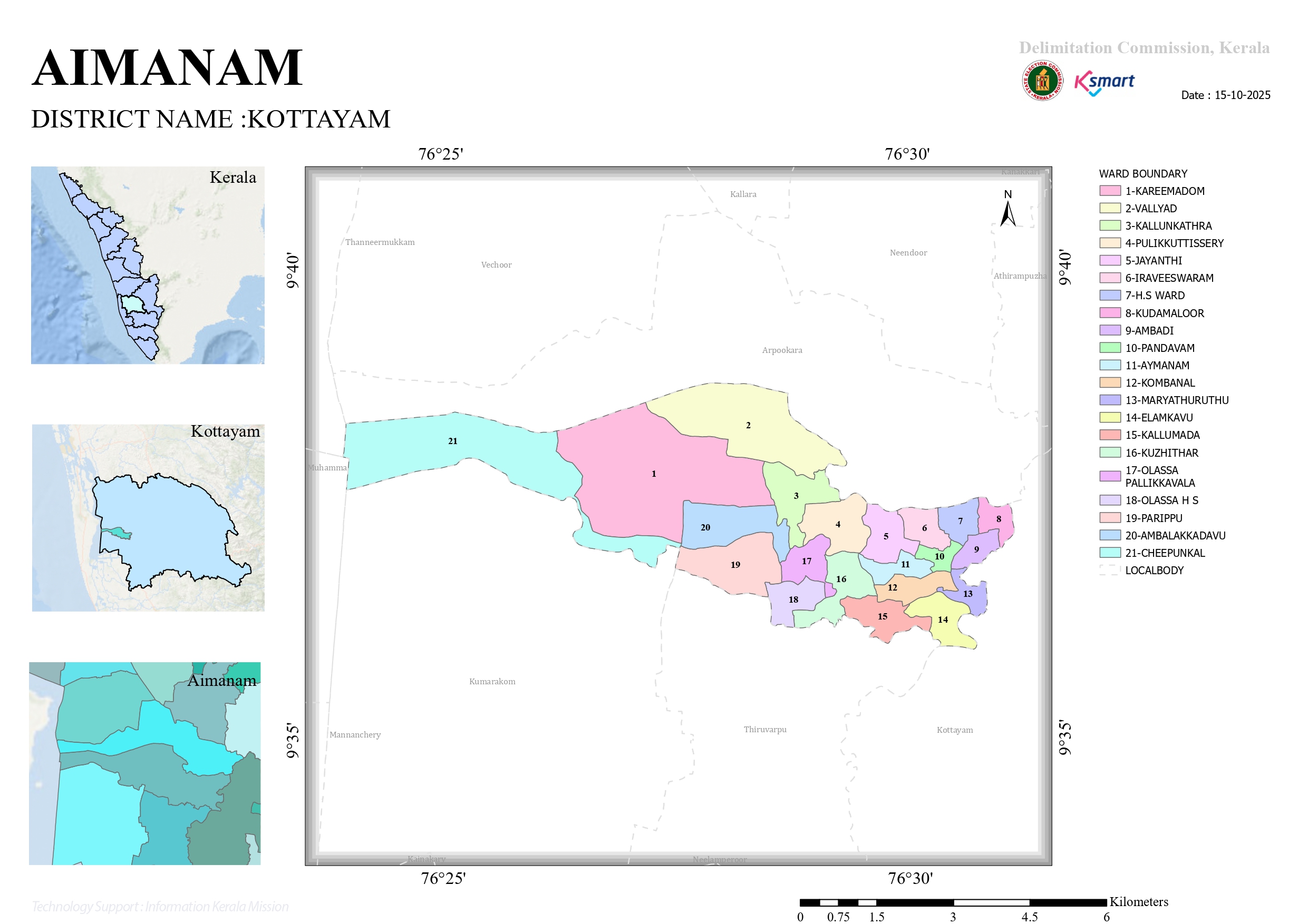
Ward Map 2025
Aymanam Grama Panchayat Ward Delimitation Map Report
This is the official ward delimitation map of Aymanam Grama Panchayat, located in Kottayam district, Kerala, prepared by the Delimitation Commission, Kerala. The map was created on 15-10-2025 with technical support from kSmart and Information Kerala Mission.
Key Details
District: Kottayam
Local Body: Aymanam Grama Panchayat
Total Wards: 21 wards
Ward Details
According to the map legend, Aymanam Panchayat has been divided into the following 21 wards. Each ward is marked in a different color on the map:
Ward No. | Ward Name
1 | Kareemadom (KAREEMADOM)
2 | Vallyad (VALLYAD)
3 | Kallunkathra (KALLUNKATHRA)
4 | Pulikkuttissery (PULIKKUTTISSERY)
5 | Jayanthi (JAYANTHI)
6 | Iraveeswaram (IRAVEESWARAM)
7 | H.S Ward (H.S WARD)
8 | Kudamaloor (KUDAMALOOR)
9 | Ambadi (AMBADI)
10 | Pandavam (PANDAVAM)
11 | Aymanam (AYMANAM)
12 | Kombanal (KOMBANAL)
13 | Maryathuruthu (MARYATHURUTHU)
14 | Elamkavu (ELAMKAVU)
15 | Kallumada (KALLUMADA)
16 | Kuzhithar (KUZHITHAR)
17 | Olassa Pallikkavala (OLASSA PALLIKKAVALA)
18 | Olassa H.S (OLASSA H S)
19 | Parippu (PARIPPU)
20 | Ambalakkadavu (AMBALAKKADAVU)
21 | Cheepunkal (CHEEPUNKAL)
Location: On the left side of the map, maps of Kerala and Kottayam district are provided to indicate the exact location of Aymanam.
Ward Size: Upon examining the map, Ward 1 (Kareemadom) and Ward 21 (Cheepunkal) appear to be among the larger wards in terms of area. In contrast, the wards located in the eastern and southeastern parts are comparatively smaller.
Boundaries: The map also shows the boundaries of neighboring local bodies around Aymanam Panchayat using dotted lines. It indicates that the panchayat shares borders with areas such as Kumarakom, Vechoor, Arpookkara, Thiruvarpu, and Kottayam Municipality, which are situated along the Vembanad Lake.